agrizone
AgriZone is an advanced location-based task management platform designed to solve the operational complexities of vast, dispersed areas like large farmlands and industrial sites. The core value proposition is the precise alignment of personnel, tasks, and geography. The application allows managers to define specific work areas using custom geo-fenced shapes (polygons) on a map and assign tasks directly to them. This eliminates ambiguity and enhances efficiency by automatically providing workers with real-time contextual data, including the area's size and micro-weather conditions.
00

problem
Managing large, dynamic, and geographically dispersed operational areas (like large-scale farms, construction sites, or industrial parks) leads to significant inefficiencies. Managers lack visibility into their team's real-time location and progress, resulting in ambiguous task assignments (e.g., "Clean the south field"), inadequate contextual data (e.g., not knowing the micro-weather conditions of a specific section), and delayed task completion notifications. This poor geospatial coordination and team accountability cause wasted time, increased operational costs, and lost productivity.
solution
AgriZone is a location-based task management platform that provides a single source of truth for all field operations by integrating geospatial data with team workflows. The app enables managers to use custom geo-fenced shapes to define operational areas precisely (e.g., "Harvestable greens") and assign tasks directly to those digital boundaries. This system ensures efficiency by augmenting each task with critical contextual information, such as the area's size and real-time weather data, ensuring the assigned worker has full awareness before starting. Crucially, AgriZone ensures accountability through automated notifications, alerting managers when team members enter or leave a designated area, thereby verifying their physical presence. Furthermore, each geo-fenced shape automatically creates a team collaboration channel, allowing for real-time chat, task updates, and media sharing (like progress photos) directly linked to that specific location, ultimately guaranteeing the right person is at the right coordinate with the full context needed for optimal operational performance.
The project originated with a client who managed vast physical assets, specifically, large commercial farmlands and industrial zones. Their central, crippling problem was geospatial chaos. Managers could assign tasks (e.g., "Harvest the corn"), but without absolute clarity on where that task began and ended, teams wasted countless hours searching for the right spot or performing work in the wrong area.
The Concept
The core concept for AgriZone was to create a geospatial operating system that eliminated all ambiguity. This meant moving beyond simple GPS pins and allowing managers to draw and name the actual boundaries of their work. The platform had to serve two primary functions simultaneously:
Precision Mapping: Create highly detailed, custom-defined digital boundaries for physical areas.
Location-Enforced Accountability: Tie tasks, teams, and real-time monitoring directly to these boundaries.
The Design Solution
As the UI/UX Designer, I built the solution with a focus on simplicity and powerful integration. The design uses a clean, authoritative color palette of deep blue and white to convey operational professionalism and clarity. Key design elements included:
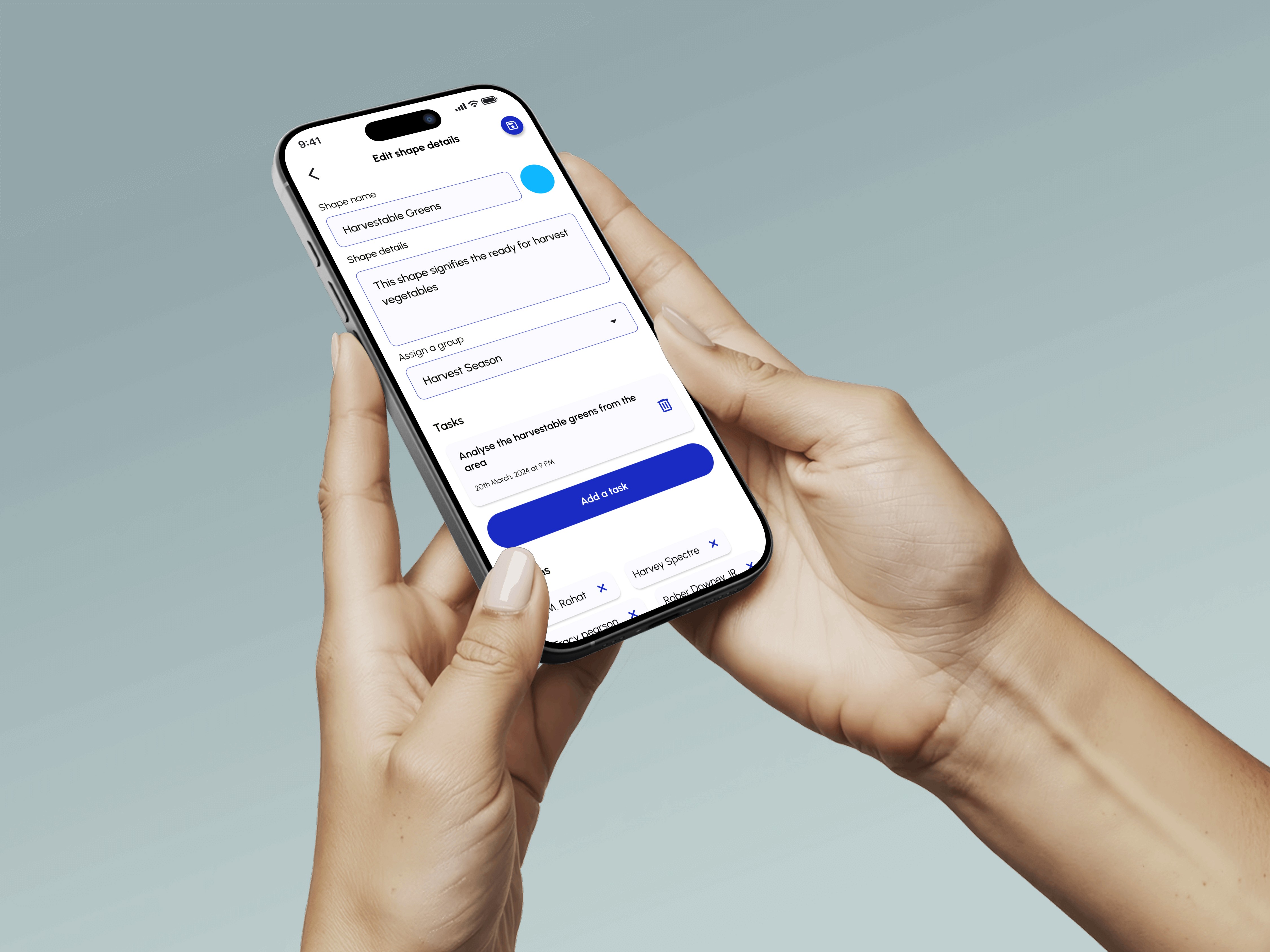
Custom Geo-fenced Shapes: The most vital design feature was the ability for users to "Mark your area with shapes" (polygons on a map). Each shape acts as a unique data container, named after the physical area (e4.g., "Corn field," "Harvestable greens"), ensuring tasks are pinned to the precise location.
Contextual Data Display: The information architecture within each shape was designed to provide immediate context. We integrated area size (sq km) and real-time weather conditions (temperature, humidity, wind) directly into the task view. This allows managers to make informed decisions about task timing, while workers know exactly what conditions to expect.
Automated Accountability: To solve the problem of team visibility, I designed automated, location-based notifications. The system actively alerts the manager when a team member "has entered the area" or "has left the area." This provides a non-intrusive, verified record of presence.
Integrated Team Communication: To foster collaboration, every geo-fenced shape automatically creates a dedicated team channel for chat and media sharing, ensuring all conversations and progress photos relate specifically to that one field or zone.
The Results
The design successfully delivered a high-fidelity, industrial-strength application. AgriZone transforms chaotic field management into a coordinated, data-rich operation. By fusing digital task assignment with real-time geospatial enforcement, the platform ensures that team accountability and operational efficiency are maintained across the largest of physical landscapes, positioning it as a leader in specialized, location-based logistics.
01

Channels and personal texts to stay updated with everyone.
02

Area specific task management
03

Notifications to stay updated on the organizational tasks
see also


